|
Coal Mining in Monroe
County
AVERAGE
ANNUAL PRODUCTION, 1901-1910 ............1,014 TONS.
Aside from unconsolidated deposits of drift and alluvium, the
surface formations of the greater part of Monroe
county are Missis-
sippian in age and are consequently barren of coal. As shown on the
State geological map, however, the main body of the Pennsylvanian
Coal Measures occupies considerable areas in the higher lands in the
western, southern, and southeastern portions of the region, and several
large outliers appear in the northeast corner. The strata represented
belong to the Cherokee shale and embrace the section from its base to the
Summit cap-rock, though in much of the area the Mulky cap is the highest
rock seen.
The overlap to the east of the Cherokee upon the Mississippian
has its effect upon the stratigraphy of Monroe county.
The Lower
Coal Measures strata found in Randolph county on the west thin out
toward the east, so that at Paris the Mulky coal lies near the Missis-
sippian, instead of 100 feet above it, as at Yates. An important factor
in this thinning is a decrease in the thickness of the Lagonda shale,
which occupies the interval between the Bevier and Mulky coals; in
Monroe county the Bevier bed is only 10 feet
or less below the Mulky.
The limestones between the Bevier and Tebo coals, so conspicuous in
other areas, are represented only by very thin bands and by concre-
tionary nodules in a clay matrix, except in the northeastern townships,
where a sump-rock is better developed. The Tebo coal is persistent
at about 20 feet below the Bevier. Below the Tebo a short, somewhat
variable interval is filled chiefly with shale and fire clay with here and
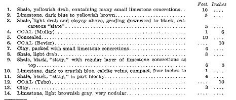
there a lenticular coal bed. The following section, measured along
Pedee and Baker branches, near Madison, may be considered typical
of the stratigraphic succession in the county:
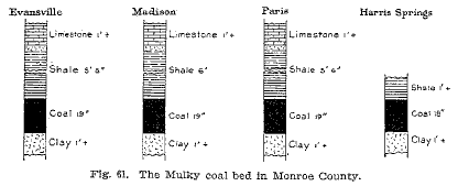
The
region is not rich in coal deposits, only one thin bed, the
Mulky, being of economic importance. This bed is very regularly 18
to 20 inches thick, except in the southeast corner of the county, where
it is somewhat thicker. It has an excellent roof of firm "slate"
that
makes ideal longwall working. The coal is of good quality, containing
a moderate amount of pyrite ("sulphur") in thin streaks and
white
gypsum scale in the joint planes. The Bevier bed, which is worked
so extensively at Huntsville, Higbee, and Bevier, is less than one foot
in thickness where seen in this county and is probably too thin to work in
all parts of the region. The Tebo coal is likewise very thin
in most places, though near Mud creek it is 18 inches thick and has
been mined a little. Lenticular coals lower than the Tebo may exist,
but, if they do, they are workable only in small areas. The Summit
coal, 30 feet above the Mulky and with very similar capping materials,
is found only in T. 55 N., R. 12 W., near the Randolph county line,
where it is about 16 inches thick.
A
study of the sections shows that the Mulky bed is easy to
identify in all outcrops in which the Summit coal is absent. Aside
from the Summit, the Mulky is the only bed having a thick limestone
cap-rock separated from the coal by 4 1/2 to 8 feet of shale that is
"slaty" and contains limestone concretions in the lower part.
The
cap-rock thickens toward the east, increasing from 4 feet near Evans-
ville to 15 feet northeast of Santa Fe, and as it thickens it loses its
even-bedded and perpendicularly jointed character. The Summit cap-
rock is much like that of the Mulky, but is more massive and breaks
more readily into rhomboidal blocks. On weathering it assumes a gray
color, whereas the Mulky becomes dark brownish drab. The shale
between the Summit cap and coal is, moreover, thinner than that
above the Mulky bed. The only coal mined for sale in Monroe
county
is taken from the Mulky bed by small local drifts near Evansville,
Madison, Paris, and Middle Grove, each mine employing only a few
men.
|